 Getting on with my life and thinking about things.


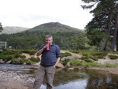





After Ben Wyvis on Friday, we drove to Loch Cluanie. I was running slightly late because of stopping and taking photos like these.
But was then further delayed by rescuing a mini-bus of dusky maidens heading to Skye. Nobody bothered stopping to help a vehicle with its hazards flashing. For 3 1/2 hours. Ceud mile failte my erse.
So, it was after 9pm by the time we left the second car at Lundie (the first was left at the finish point near Caorann Bridge).
300m of ascent to a pitch for the night and Friday was finally over.
===
Simon's Akto on the left, mine on the right. The side-opening doors allows a civilised throwing of biscuits, weather reports, etc, between tents whilst the main body is still parallel with the wind direction.
We're at 540m, with Loch Cluaine below and South Shiel to the...well, south.
After breakfast and breaking camp, this is the morning clamber up to the 900m plateau of Carn Ghluasaid. Less than a 400m ascent - one of the advantages of wild camping.
We would be skirting the upper edges of this Coire later in the day. It contains Gorm Lochan - invisible until we were right above it.
The low cloud would be at about 940m elevation almost all day. Here, Simon's following the path to Carn Ghluasaid. Considering how rocky and bumpy the plateau is, and how many cliffs there are around - you really don't want to get lost here.
We caught a glimpse of Sgurr nan Conbhairean through the cloud.
Simon and me on the summit of Carn Ghluasaid [Munro 34, 957m/3140ft]. I've had to lighten the picture as the clouds played havoc with the camera's automatic settings.
Much of the 3km trek to Sgurr nan Conbhairean was in this weather. I kept the waterproof layer on until we were off the hill on Sunday.
Simon on Sgurr nan Conbhairean.
Duncan on Sgurr nan Conbhairean [Munro 35, 1109m/3638ft]. Okay, so I didn't notice that I had the buff on upside down.
Looking back towards Sgurr nan Conbhairean. The trek to Sail Chaorainn involves dropping down to 914m and then back. We would contour the Sgurr to the right of this shot on our way to that night's pitch.
Dropping down below the cloudmass opened up enticing views, like this one of Coire nan Lochan Uaine.
Duncan on Sail Chaorainn [Munro 36, 1002m/3287ft]. We passed a chap who described the route to the Munro as being past here and with a bit of a "down and up" section. We reckoned he'd overshot. The gps came in handy, though the altimeter was being fooled on occasions by the cliffs. 7m accuracy on a ridge can be a bit lower than the path.
Heading back to Sgurr nan Conbhairean from the third and final Munro of the day. We would contour round the Sgurr.
Contouring lower from Sgurr nan Conbhairean opened some great views. Here, Allt nan Lochan Uaine.
And, Gorm Lochan, concealed from below by the corrie lip.
Walking over Drochaid an Tuill Easaich with A'Chralaig beyond and a bealach in between.
Sail Chaorainn in cloud, showing what we had walked through. We pitched by an unnamed lochan, which I wanted to name lochan nan doirbeag as it was home to the wee things. I even had one swimming in my hydration sack before releasing Nemo back to the wild. It might explain the cats - named on the map, but missing from view. Cup of tea, dinner, snacks and listened to the news, relaying information about the flooding to Simon's tent. BBC Scotland then had a piping show, starting with "The Cameronian Rant" - threatening to put this on the radio's speaker rather than earpiece, we joked about cairns, wind factories, pylons and other topics in the tune.
We had trekked 14km and were camping at 890m altitude. Four Munros in 48 hours and two more on Sunday, hopefully. I went to sleep trying not to worry about words like exposed, airy, interesting, pinnacles. At least I wasn't thinking about paperwork.
Sunday, 22 July 2007
Cluanie horseshoe day 1


![Carn Ghluasaid [Munro 34, 957m/3140ft]](https://lh3.googleusercontent.com/blogger_img_proxy/AEn0k_uaLqoC2nEJ0glXgABOID0RLcKQROWazNNbJG05NwOOc4WoTras3JbrZe4s0UOMpxwz5OTXI2WluAPjI5L0dmuoFVJuy2I3huV0EJbcb8dfCUk9a4sTDWSYJMs6Ow6atw=s0-d)


![Sgurr nan Conbhairean [Munro 35, 1109m/3638ft]](https://lh3.googleusercontent.com/blogger_img_proxy/AEn0k_v8Y_-4_4zSRgC12rwgjg6mGD7DFUQ_2CVVC1aE3r-fnkHUGqiueP-77lv8EQiHUQHAGXfgexrM8sL4HfsuuB0EcdesraOY4mdm-9G_a5sNejc9H8If7ixaeUbcl_vT=s0-d)


![Sail Chaorainn [Munro 36, 1002m/3287ft]](https://lh3.googleusercontent.com/blogger_img_proxy/AEn0k_sOlt6ukT3Q1v7KgpNviWL6qjZmQ7PR4dC2GHxGHIeSq1nBUhxGcLyau67vx6453PlAWOJzn9vx_ys2wSspCkVvzrD4KbvblrmoyCNpqTYH7MCxjCHzemcJ8_6SIOZG=s0-d)


Friday, 20 July 2007
Ben Wyvis
I met Simon in the Ben Wyvis car park and we set off at 10am.
The SMC book describes Ben Wyvis as being "often capped with cloud".
Looking up Allt a'Bhealaich Mhor, with Little Wyvis on the right and the start of Ben Wyvis on the left. Cattle used to be driven through this valley.
Simon fills his water bottle (it's in his hand) at the last waterstop before we come back off the hill.
Looking over Loch Glascarnoch.
Simon being nonchalant.
Cattle used to be driven through the valley below on their way to markets all over the country. This valley bypasses Garve.
The path up An Cabar.
A clearer view towards Dingwall.
Two ladies out for a walk up the Munro.
Once on An Cabar, the path to Glas Leathad Mhor is grand, especially when the cloud has lifted.
Simon on Glas Leathad Mhor, Ben Wyvis' Munro.
Duncan on on Glas Leathad Mhor/Ben Wyvis [Munro 33, 1046m/3432ft]
Coire na Fiola. Looks like a nice place to hide cattle.
Heading for Tom a' Choinnich, we had come off the Munro just in time for the cloud to settle back in for the afternoon.
Stepping down off the shoulder of Tom a' Choinnich, we were heading for the treeline.
Resting at Allt a' Gharbh Bhaid, and looking back up the slope of Tom a' Choinnich, Ben Wyvis' northern top.
Almost back at the track to the car park. A 7 hour trek. Once there, we agree to meet up in Drumnadrochit for tea and then head for Cluanie, and the next part of the trip.
I got slightly delayed by scenes like this as I drove down Loch Ness.


![Ben Wyvis [Munro 33, 1046m/3432ft]](https://lh3.googleusercontent.com/blogger_img_proxy/AEn0k_uNSMw8yKEXROzG7IEEhAWD4gU_fyfS3AxVC3lDs4PklKiGO7mi6qE7wYjeznS4CxFDOf2saZHD4H5GKoXvxb385JAgIPOJkLnRjWmkn7HWUs-o-lTO8DP7DXKXwwW5=s0-d)


SeAL
Spent much of the Minch crossing taking photos of the sea, air and land. Especially the play of light on them. Sadly, the best light was mostly lost by me being in the queue of cars waiting to board the ferry.
Goat island, Stornoway.
Beasts of Holm.
Point.
South Lochs, with the Harris hills behind.
North-west Highland hills as the ferry sails towards Loch Broom.


Thursday, 19 July 2007
Engebrets
Engebret's Filling Station and Shop, Sandwick Road, Stornoway. They have maps, books, even saw some Haglof kit and a collection of Optimus Prime stoves. And the gas to run them. Lots of other mundane things like magazines, food, drink, oh, and petrol/diesel.
Nothing compared to where Roman hopes to be going in a couple of days time. But I'll make do with a copy of Colin Demét's "Cúchulainn" (publisher: Wordcatcher). Summary of the hero's life on Wikipedia.
Tuesday, 17 July 2007
European OutDoor
Friedrichshafen. They have a zeppelin museum. Nice.
Oh, and the annual outdoor gear show is happening there shortly.
Air pirates. Outdoor gear. Is there a link? I blame Studio Ghibli
Trail will be there (Gear blog), not sure if Chris Townsend is going. I don't have my copy of TGO here to check.
Drove Roads of Scotland
"The Drove Roads of Scotland" by A.R.B. Haldane (publishers: Birlinn)
This was the 'other' book that I didn't buy when I bought the book on cattle raiding.
Researched over a decade from 1942, the author spoke to some old drovers, still alive:
There are still (1952) men living who have seen the cattle boats sailing into Loch Dunvegan with the Uist droves, or the ferry boats from Lagg bringing the Islay cattle across the Sound of Jura. Others tell how they helped in their youth to bring droves from Kintyre and Knapdale by Inveraray and Loch Lomond to Falkirk, or from Don-side across the Dee to the Angus glens on the road to Perth. Their part in the last of the droving days is recalled with pride in an old and honourable trade; with regret too for the passing of the peace of mind and the contemplative outlook of those less hurried days.
The brown sails of the cattle boats have gone from the Minch. On slipways and jetties from Skye to Kintyre thrift grows undisturbed in the crannies of stones once smooth and polished with the tread of hooves. The hills round Loch Ainort look down on lonely saltings where the Uist droves once grazed, while throughout the Highlands, in hill pass, moorland and upland valley, as in the minds of men, the passing years increasingly dim and obscure the mark and memory of the men and the beasts that once travelled the drove roads of Scotland.
I look forward to reading this book. Skimming through it, I read that cattle were driven over the "saddle between Ben Wyvis and Little Wyvis" as a shortcut on the road to Dingwall. And area I may be hiking in on Friday.
Sunday, 15 July 2007
Sunny Sunday
Sun finally broke through on Sunday evening. I reckon for the first time in 10 days, but I could be mistaken. Took camera off down Broad Bay to Traigh Mhor.
Broad Bay, towards Tiumpan Head Lighthouse. Mainland hills beyond.
Above: Traigh Mhor looking northwards.
Below: Traigh Mhor looking southwards.


TGO LoM
Okay, so it's just a bit of computer trouble across at the TGO forum, but I get the mental image of Cameron in a sheepskin coat, fitting up some nonce who doesn't agree with lightweight hiking, whilst Chris T is wondering where his GoreTex has gone.
ToR links: one, two.
For more information, call Hyde 2612
Saturday, 14 July 2007
Na Drobhairean
Caught part of an intriguing programme on TeleG, the local Gaelic Community Channel: "Na Drobhairean" (The Drovers).
Presenter Peter Macaulay will examine the ways in which the drovers enriched the songs, stories and poetry of the Highlands...Scotland's drovers enhanced the economic well being of rural communities as they plied their trade from the north and west to the markets of the lowlands. They also contributed a great deal to the culture of the country. (link)
Supermarkets Swept
A number (maybe 11, maybe around 14) Tesco supermarkets have been closed by police across the UK today. News broke around 7pm tonight. When we checked BBC News online, a webpage hadn't been created for it, and it was just a "breaking news banner". BBC News24 on Freeview were asking viewers for information.
Shortly afterwards a webpage was created here; and the public were sending in reports and photos to the BBC tv news. By 8.20pm, the BBC had their own footage of a closed Tesco store.
Some shops had been closed just after noon (1230BST).
If you notice the time delay, and the lack of professional journalists being involved, maybe the question shouldn't be about the rise in user generated content, but the reliance by professionals on user generated content. Did the BBC chiefs sack all the local journalists in the last pay cuts? Six hours, and no-one at the news desk got wind of a story?
Am I being unkind? Police cordons, supermarkets shut, nothing, not important. Not newsworthy - like a LEJOG walk, it happens daily. But 11+ across the UK? Even Julia Sawalha in a dressing gown would have found a story there (ToR link).
Arai Tents
So, as the day is still overcast, I went for a wonder round the Net and found Arai Tents in Japan. Some nifty shapes of their shelters. If you have the right fonts, and don't need the translation page, click this link.
A Google of the tent gave me Daisuke Takeda's site (famous surname, Daisuke). Motorcycling around Japan, he wishes not to be added to the Engrish.com site.
Once more, I feel bad at not being able to speak a foreign language. So much for that jaunt round the Net cheering me up. Is it wrong to find humour in the fact that people have difficulty communicating in a foreign language? Although I think this means what it says. And this could be a new Gordon Brown initiative to retrain druggies. At least it's not "Tintin in the Congo"!
Rainy Days
As the weather seems to be set in its ways, I'm loading up the mobile phone with some podcasts to listen to without the old computer groaning under the weight.
Some of Bob's from The Outdoors Station can be found via iTunes or links on OM. Others are coming from the US BackpackingLight.com site.
I've previously tried using my iPod as an mp3 player (if you catch my drift), but it caused serious problems when I later tried to re-sync it to the base computer. So much so, that I can't be bothered risking it. So, another piece of gear that I don't trust to do its core job (portable entertainment).